The European Commission/Erasmus+-funded GeoDRR Project has the objective of developing and providing a Master’s program in Geomatics for Disaster Risk Reduction (MGeoDRR). This initiative involves the active participation of nine institutions, including universities in Poland (Silesian University of Technology), Spain (University of Alicante), Greece (University of West Attica), Cambodia (Svay Rieng University), and Malaysia (Universiti Utara Malaysia & Universiti Sains Malaysia), as well as universities in the Philippines (University of the Cordilleras & Xavier University – Ateneo de Cagayan), and a consulting firm in Luxembourg (Novel Group). The University of the Cordilleras has allocated a funding of 5 million for a three-year project duration.
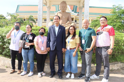
During the annual meeting and workshop of the project, the University, with Engr. Nathaniel Vincent A. Lubrica as the project leader, actively took part in the Educational Workshop. This workshop took place from July 18 to 22, 2022, at Svay Rieng University in Cambodia.
The primary outcome of this workshop was the development of a Disaster Risk Reduction (DRR) syllabus. This syllabus was created through the exchange of best practices among participating universities, focusing on innovative solutions for DRR. This collaborative effort aimed to enhance the educational tools and resources available for addressing disaster risk reduction effectively.
The five-day workshop in Cambodia featured a comprehensive agenda. Here’s a summary of the key topics covered each day:
Day 1: The training commenced with an introduction to the basic concepts of Geographic Information Systems (GIS) and Remote Sensing, led by Dr. Krzysztof Tomiczek, the Project Manager.
Day 2: The second day was divided into two main segments. In the morning, the focus was on Teaching Pedagogy, and the session was conducted by the Silesian University of Technology. In the afternoon, methodologies and applications for monitoring slope and landslide stability were explored.
Day 3: The third day delved into Geo-spatial analysis of Multi-Hazard Risk, a session presented by Assistant Professor Vasileios Krassanakis.
Day 4: On this day, the agenda centered on Safety Road Inspections, with insights provided by Dr. Dimosthenis Pavlou.
Day 5: The final day of the workshop included a session with the National Institute of Education (NIE) regarding the work package, likely involving discussions on project-related activities and future plans.
This comprehensive program covered various aspects of Geographic Information Systems, teaching methods, hazard analysis, road safety, and project-related discussions, contributing to a well-rounded educational workshop.
